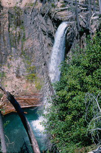
 PARADISE FALLS
RATING: **
ACCESS: trail and bushwhack (hard)
FORM: plunge
MAGNITUDE: 75
ELEVATION: 2100 feet
WATERSHED: large
USGS MAP: Smith Creek Butte (2000)
NAVIGATION MAP: Click Here
)
LATITUDE: 46.233213° N
LONGITUDE: 122.010503° W
EDITION: 5th
DESCRIPTION: Gain an exciting, albeit obscured gorge-rim view of this 133-foot plummet along Clearwater Creek. Located within a seldom visited part of Gifford Pinchot National Forest administered by Mount St. Helens National Volcanic Monument.
DIRECTIONS: Several decades ago the author was allowed to document this waterfall, but could not advertise it due to road closures. The roads are now open, but only to hikers rather than vehicles. Drive 0.9 miles north of Clearwater Overlook, located along Randle-Lewis River Road #25 about halfway between its junctions with FR #93 and FR #99. Park in a safe spot and embark upon FR #2560 to your left (west), winding your way down to the valley floor in 2.5 miles. Turn left here upon FR #2568, heading southward. Hike another 2.5 miles, where a gorge opening to your right should become apparent. Take a fairly easy bushwhack to its rim and find a vantage of the falls that will be to your right. The cliffs are very dangerous here, so stay at the rimtop.
During the Summer of 2012, the author learned of a route that cuts off nearly five miles on the round trip, but he has not a chance to field verify it. The reliable source says to drive 3.2 miles south of Clearwater Overlook and park safely at FR #25-540. While the road ends in 2.2 miles, a footpath resumes at its terminus, ending 0.4 miles further at FR #2560 near the gorge.
Copyright 2013 by Gregory A. Plumb GUIDEBOOK published by Mountaineers Books