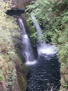
 DESCHUTES FALLS
RATING: **
ACCESS: hike (easy)
FORM: segmented
MAGNITUDE: 38
ELEVATION: 770 feet
WATERSHED: lg
USGS MAP: Bald Hill (1990)
NAVIGATION MAP: Click here
LATITUDE: 46.802694° N
LONGITUDE: 122.415321° W
EDITION: 5th
DESCRIPTION: Situated 100 feet downstream from Upper Deschutes Falls (described earlier), Deschutes River splits 35 feet downward within a small gorge. Located within Deschutes Falls County Park.
DIRECTIONS: Tucked in the far southeast corner of Thurston County, this entry and its counterpart are not yet accessible to the general public. Sometimes group trips are led by Department of Parks & Recreation. Check their web site for the next 0.2-mile hike to the falls.
Copyright 2013 by Gregory A. Plumb GUIDEBOOK published by Mountaineers Books