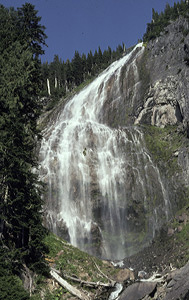
Tom Tom Falls
Rating: **
Form: horsetail
Magnitude: 28
Access: trail and bushwhack (page 93)
USGS Map: Eatonville (1990 ns)
Little Mashel Falls
Rating: ***
Form: fan
Magnitude: 48
Access: trail and bushwhack (page 93)
USGS Map: Eatonville (1990)
New Entries Others
Copyright 2011 by Gregory A. Plumb
Lower Little Mashel Falls (u)
Rating: **
Form: segmented
Magnitude: 59
Access: trail and bushwhack (page 95)
USGS Map: Eatonville (1990 ns)
Click Here for Victor Falls, USGS Sumner (1993).
Click Here for Upper Deschutes Falls (u), USGS Bald Hill (1990 ns).
Click Here for Deschutes Falls, USGS Bald Hill (1990).
Format the pages to match your hardcopy book by changing your printer settings to 9" x 5 3/4".
Wildcat Falls, USGS Lake Kapowsin (1993),
is on private property with no access found. Not much is known
about getting to Voight Creek Falls (u), USGS USGS Wilkeson (1994 nl),
Middle Voight Creek Falls (u), USGS USGS Wilkeson (1994 nl), or
Upper Voight Creek Falls (u), USGS Wilkeson (1994 nl).
Go to next section of Mount Rainier
Go to previous section of Mount Rainier
Mount Rainier Contents
Mount Rainier Index
Master Table of Contents
Master Index
Perform a Selective Search
View Chronogical List of Additions
View Chronogical List of Updates
Place
a Book Order Online
GUIDEBOOK published by
Mountaineers Books