 CALDRON LINN
RATING: * *
ACCESS: hike (fairly easy)
FORM: tiered
MAGNITUDE: 41
ELEVATION: 3920 feet
WATERSHED: large
USGS MAP: Murtaugh (1992)
NAVIGATION MAP: Click Here
)
LATITUDE: 42.49576° N
LONGITUDE: 114.12959° W
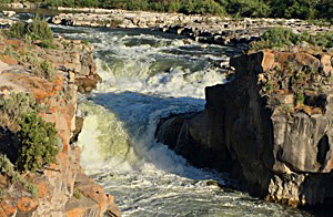
DESCRIPTION: The descent occurs where the Snake River squeezes through a narrow 25-foot notch at the floor of its canyon, dropping a total of 25 to 30 feet. The amount of water can vary tremendously, depending how much is being released upstream at Milner Dam. Whan at high flow, this entry deserves a higher rating, as it turns into a segmented form with the otherwise dry far side possessing a block form. Linn is Scottish for falls.
DIRECTIONS: Depart U.S. 30 at the sign for the communty of Murtaugh. After 1.7 miles, bear left and cross the railroad tracks upon Murtaugh Road. Turn left again in 0.6 miles. Cross over the Snake River and in 1.6 miles turn right (east) upon Road 1475, which should be signed for Caldron Linn. Proceed 1.0 miles, then turn right (south). Parking for the falls is near the end of the road in 1.1 miles. Walk down the thin path for 0.1 miles to rimside vantages. Unprotected, so not recommended for skittish persons or rambunctious kids.
Web page ©2018 by Gregory A. Plumb GUIDEBOOK published by Mountaineers Books