 Falls
City Falls (u)
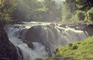
Falls
City Falls (u)
Rating: **
Form: block
Magnitude: 57
Access: auto (page 240)
USGS Map: Falls City (1974 nl)
Edition: 1st
Falls
City Falls (u)
Rating: **
Form: block
Magnitude: 57
Access: auto (page 240)
USGS Map: Falls City (1974 nl)
Edition: 1st
Others Maps show Private Road labels in association with the following cataracts:
Camp Creek Falls (u), USGS Laurel Mtn (1974 nl),
Mill Creek Falls (u), USGS Laurel Mtn (1974 nl),
Rock Creek Falls (u), USGS Midway (1979 nl),
Lower Rock Creek Falls (u), USGS Midway (1979 nl),
Little Luckiamute Falls (u), USGS Fanno Ridge (1974 nl),
Valsetz Falls, USGS Valsetz (1974 ns),
Boulder Creek Falls (u), Warnicke Creek (1974 nl),
Central Line Creek Falls (u), USGS Warnicke Creek (1974 nl),
Crowley Mine Falls (u), USGS Warnicke Creek (1974 nl),
East Crowley Forks Falls (u), USGS Warnicke Creek (1974 nl),
West Crowley Forks Falls (u), USGS Warnicke Creek (1974 nl),
Little Boulder Creek Falls (u), USGS Warnicke Creek (1974 nl),
East Rock Valley Falls (u), USGS Warnicke Creek (1974 nl),
Middle Rock Creek Falls (u), USGS Warnicke Creek (1974 nl),
Far Rock Creek Falls (u), USGS Warnicke Creek (1974 nl),
Upper Rock Creek Falls (u), USGS Warnicke Creek (1974 nl),
West Rock Valley Falls (u), USGS Warnicke Creek (1974 nl),
Warnicke Creek Falls (u), USGS Warnicke Creek (1974 nl), and
Warnicke Valley Falls (u), USGS Warnicke Creek (1974 nl).
When field-truthed, Berry Creek Falls, USGS Falls City (1974),
was found to be in a restricted municipal watershed. Silver Falls, USGS Laurel Mtn (1974), appears adjacent to clearcuts on aerial imagery, so is not likely accessible.
Go to first section of next chapter (South Coast Range)
Go to previous section of North Coast Range
North Coast Range Contents
North Coast Range Index
Master Table of Contents
Master Index
Perform a Selective Search
View Chronological List of Additions
View Chronological List of Updates
Place
a Book Order Online
Copyright 2013 by Gregory A. Plumb
GUIDEBOOK published by
Mountaineers Books