 Wallowa Falls
Rating: ***
Form: punchbowl
Magnitude: 52 (h)
Access: trail and bushwhack (page 331)
USGS Map: Joseph (1990 nl)
Edition: 1st
Wallowa Falls
Rating: ***
Form: punchbowl
Magnitude: 52 (h)
Access: trail and bushwhack (page 331)
USGS Map: Joseph (1990 nl)
Edition: 1st
Others COPYRIGHT 2013 by Gregory A. Plumb
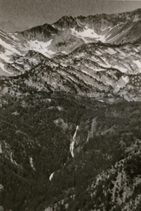 Adam Creek Falls
Rating: ***
Form: tiered
Magnitude: 66
Access: gondola or trail (page 332)
USGS Map: Eagle Cap (1990 ns)
Edition: 1st
Use the following Waterfalls for Intrepid Explorers hyperlink to access an index for information on exploring the following waterfalls yet to be visited by the author:
Imnaha Falls, USGS Deadman Point (1990)
Copper Creek Falls, USGS Bennet Peak (1990)
East Fork Falls, USGS Cornucopia (1990)
West Fork Falls (u) USGS Cornucopia (1990 nl)
Pine Lakes Falls (u) USGS Cornucopia (1990 nl)
Kettle Creek Falls (u), USGS Krag Peak (1990 nl)
Go to next section of Columbia Plateau
Go to previous section of Columbia
Plateau
Columbia Plateau Contents
Columbia Plateau Index
Master Table of Contents
Master Index
Perform a Selective Search
View Chronological List of Additions
View Chronological List of Updates
Place
a Book Order Online
GUIDEBOOK published by
Mountaineers Books