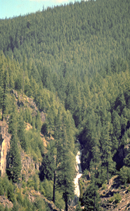
 Devil Canyon Falls (u)
Rating: **
Form: tiered
Magnitude: 54
Access: auto (page 257)
USGS Map: Government Camp (1997 nl)
Edition: 1st
Devil Canyon Falls (u)
Rating: **
Form: tiered
Magnitude: 54
Access: auto (page 257)
USGS Map: Government Camp (1997 nl)
Edition: 1st
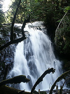
 Little Zigzag Falls
Rating: **
Form: fan
Magnitude: 45
Access: trail (page 257)
USGS Map: Government Camp (1997 ns)
Edition: 3rd
Others
COPYRIGHT 2013 by Gregory A. Plumb
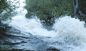
 Yocum Falls
Rating: ***
Form: fan
Magnitude: 46
Access: trail (page 258)
USGS Map: Government Camp (1997)
Edition: 5th
 Upper Yocum Falls (u)
Rating: **
Form: cascade
Magnitude: 48
Access: auto (page 259)
USGS Map: Government Camp (1997 ns)
Edition: 1st
Seven waterfalls exist within the Salmon River Gorge, part of the Salmon-Huckleberry Wilderness. Unfortunately, sources report all but one can be clearly seen and the one that is visible requires a sketchy off-trail trek to its vista. Unless/until improvements are made in the trail system, it is recommended for you NOT to seek out the following descents:
Vanishing Falls, USGS High Rock (1997),
Frustration Falls, USGS High Rock (1997),
Final Falls, USGS High Rock (1997),
Hideaway Falls, USGS High Rock (1997),
Little Niagara Falls, USGS High Rock (1997 ns),
Split Falls, USGS Wolf Peak (1997),
and Stein Falls, USGS Wolf Peak (1997).
Go to next section of Middle Cascades
Go to previous section of Middle Cascades
Middle Cascades Contents
Middle Cascades Index
Master Table of Contents
Master Index
Perform a Selective Search
View Chronological List of Additions
View Chronological List of Updates
Place
a Book Order Online
GUIDEBOOK published by
Mountaineers Books