A Waterfall Lover's Guide to the Pacific Northwest 5th ed.
North Cascades
23 Deming
Waterfall Entries (refer to hardcopy
book for descriptions and directions, page numbers are provided below)
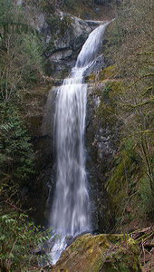 Hard Scrabble Falls
Rating: ***
Form: tiered
Magnitude: 60
Access: trail (page 67)
USGS Map: Deming (1994)
Edition: 5th
UPDATE: This waterfall is no longer accessible!
The landowner had to close the private trail due to vandalism. Go on to the next entry.
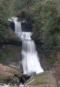 Racehorse Creek Falls (u)
Rating: ***
Form: tiered
Magnitude: 62
Access: bushwhack (page 68)
USGS Map: Maple Falls (1994 nl)
Edition: 5th
Others
When last checked, private landowners were not allowing access to either
Sygitowicz Creek Falls (u), USGS Deming (1994 nl) or
Tinling Creek Falls (u), USGS Deming (1994 nl).
Anderson Falls (u), USGS Lawrence (1994 nl), is not likely to be reached.
Go to next section of North Cascades
Go to previous section of North Cascades
North Cascades Contents
North Cascades Index
Master Table of Contents
Master Index
Perform a Selective Search
View Chronological List of Additions
View Chronological List of Updates
Place
a Book Order Online
COPYRIGHT 2013 by Gregory A. Plumb
GUIDEBOOK published by
Mountaineers Books