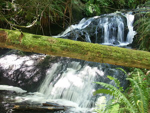
 Ludlow Falls
Rating: **
Form: tiered
Magnitude: 16 (l)
Access: trail (page 98)
USGS Map: Port Ludlow (1973 ns)
Edition: 5th
Ludlow Falls
Rating: **
Form: tiered
Magnitude: 16 (l)
Access: trail (page 98)
USGS Map: Port Ludlow (1973 ns)
Edition: 5th
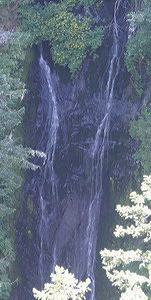 Falls View Falls (u)
Rating: **
Form: horsetail
Magnitude: 26 (l)
Access: auto (page 99)
USGS Map: Mt. Walker (1995 ns)
Edition: 1st
Others COPYRIGHT 2013 by Gregory A. Plumb
Use the following Waterfalls for Intrepid Explorers hyperlink to access an index for information on exploring the following waterfall yet to be visited by the author:
Royal Creek Falls (u), USGS Mount Deception (1990 nl)
Neither Heather Creek Falls (u), USGS Mount Deception
(1990 nl) or Wet Weather Falls (u), USGS Mount Townsend
(2000 nl) are likely accessible.
Go to next section of Olympics
Go to previous section of Olympics
Olympics Contents
Olympics Index
Master Table of Contents
Master Index
Perform a Selective Search
View Chronological List of Additions
View Chronological List of Updates
Place
a Book Order Online
GUIDEBOOK published by
Mountaineers Books