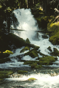
 Rough Rider Falls
Rating: **
Form: cascade
Magnitude: 44
Access: trail (page 309)
Updated Location Map: Click Here
)
USGS Map: Hamaker Butte (1999 ns)
Edition: 1st
Update: Formerly listed as Upper Rogue Falls, it now has an official name. Additionally this entry was erroneously thought in all prior editions of the guidebook to be the one mapped further upstream by the USGS. Thanks to Bryan Swan for noting this mistake from decades past.
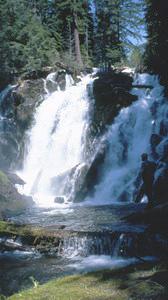 National Creek Falls
Rating: **
Form: segmented
Magnitude: 50
Access: trail (page 310)
USGS Map: Hamaker Butte (1999 nl)
Edition: 1st
More
Click Here for Middle Rogue Falls (u), USGS Hamaker Butte (1999 nl).
Click Here for Muir Creek Falls, USGS Hamaker Butte (1999 nl).
Click Here for Highway Falls, USGS Hamaker Butte (1999 nl).
Click Here for Alkali Creek Falls, USGS Hamaker Butte (1999 ns). NEW!
Click Here for Cascade Creek Falls (u), USGS Hamaker Butte (1999 nl). NEW!
Output the CLICK HERE pages to match your hardcopy book by changing your printer settings to 9" x 5 3/4".
Others
Upper Rogue Falls (u), USGS Hamaker Butte (1999 nl) and Far Upper Falls (u), USGS Hamaker Butte (1999 nl), are too deep in their gorges to be seen from
Upper Rogue River Trail.
Go to next section of South Cascades
Go to previous section of South Cascades
South Cascades Contents
South Cascades Index
Master Table of Contents
Master Index
Perform a Selective Search
View Chronological List of Additions
View Chronological List of Updates
Place a Book Order Online
COPYRIGHT 2013 by Gregory A. Plumb
GUIDEBOOK published by
Mountaineers Books