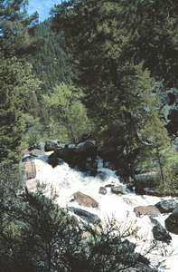
 Napias Creek Falls
Rating: **
Form: rapids
Magnitude: 32
Access: auto (page 371)
USGS Map: Jureano Mtn (1989)
Edition: 1st
Napias Creek Falls
Rating: **
Form: rapids
Magnitude: 32
Access: auto (page 371)
USGS Map: Jureano Mtn (1989)
Edition: 1st
Others
COPYRIGHT 2024 by Gregory A. Plumb
Devlin Falls, USGS Leesburg (1989), doesn't appear to be accessible.
Go to next section of
Wilderness Idaho
Go to previous section of Wilderness
Idaho
Wilderness Idaho Contents
Wilderness Idaho Index
Master Table of Contents
Master Index
Perform a Selective Search
View Chronological List of Additions
View Chronological List of Updates
Place
a Book Order Online
GUIDEBOOK published by
Mountaineers Books