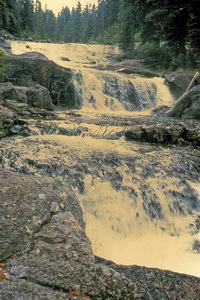
 Goat
Creek Falls (u)
Goat
Creek Falls (u)
Rating: **
Form: segmented
Magnitude: 39
Access: trail and bushwhack (page 365)
USGS Map: Edaho Mtn (1972 ns)
Edition: 1st
Photograph by Sheldon Bluestein
Goat
Creek Falls (u)
Rating: **
Form: segmented
Magnitude: 39
Access: trail and bushwhack (page 365)
USGS Map: Edaho Mtn (1972 ns)
Edition: 1st
Photograph by Sheldon Bluestein
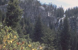
 Fern
Falls
Fern
Falls
Rating: **
Form: tiered
Magnitude: 44
Access: backpack (page 366)
USGS Map: Warbonnet Peak (1972)
Edition: 1st
Photograph by Sheldon Bluestein
Tohobit Creek Falls (u)
Rating: **
Form: horsetail
Magnitude: 42
Access: backpack (page 366)
USGS Map: Warbonnet Peak (1972 ns)
Edition: 1st
Warbonnet Falls (u)
Rating: **
Form: horsetail
Magnitude: 42
Access: backpack (page 366)
USGS Map: Warbonnet Peak (1972 ns)
Edition: 1st
 Baron Creek Falls
Rating: ***
Form: segmented
Magnitude: 56
Access: backpack (page 366)
USGS Map: Warbonnet Peak (1972)
Edition: 1st
Photograph by Sheldon Bluestein
Others COPYRIGHT 2013 by Gregory A. Plumb
Use the following Waterfalls for Intrepid Explorers hyperlink to access an index for information on exploring the following waterfalls:
Smith Falls, USGS Warbonnet Peak (1972)
Scenic Creek Falls (u), USGS Nahneke Mtn (1972 nl)
Upper Goat Creek Falls (u), USGS Warbonnet Peak (1972 nl) is not accessible.
Go to next section of Wilderness Idaho
Go to previous section of Wilderness
Idaho
Wilderness Idaho Contents
Wilderness Idaho Index
Master Table of Contents
Master Index
Perform a Selective Search
View Chronological List of Additions
View Chronological List of Updates
Place
a Book Order Online
GUIDEBOOK published by
Mountaineers Books