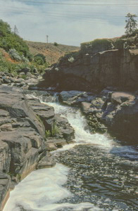
 Cushing Falls
Rating: **
Form: punchbowl
Magnitude: 13
Access: auto (page 221)
USGS Map: Petersburg (1994)
Edition: 1st
Cushing Falls
Rating: **
Form: punchbowl
Magnitude: 13
Access: auto (page 221)
USGS Map: Petersburg (1994)
Edition: 1st
More
Click Here for Petersburg Falls (u), USGS Petersburg (1994 nl).
Output the CLICK HERE page to match your hardcopy book by changing your printer settings to 9" x 5 3/4".
Others Low-lying falls once occurred along the mighty Columbia River, but have
since disappeared due to hydroelectric projects. The Dalles,
USGS The Dalles South (1994 ns), has been replaced the The Dalles Dam and
Celilo Falls, USGS Stacker Butte (1994 ns), is covered by the reservoir
created by the dam.
COPYRIGHT 2013 by Gregory A. Plumb
Use the following Waterfalls for Intrepid Explorers hyperlink to access an index for information on exploring the following waterfall:
Mill Creek Falls, USGS Brown Creek (1994)
Go to next section of Columbia Gorge
Go to previous section of Columbia
Gorge
Columbia Gorge Contents
Columbia Gorge Index
Master Table of Contents
Master Index
Perform a Selective Search
View Chronological List of Additions
View Chronological List of Updates
Place
a Book Order Online
GUIDEBOOK published by
Mountaineers Books