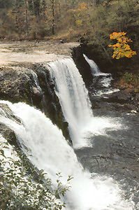
 Rock Creek Falls (u)
Rating: ***
Form: block
Magnitude: 39 (l)
Access: trail (page 224)
USGS Map: Bonneville Dam (1994 nl)
Edition: 1st
Update: 2nd Street is now signed as Rock Creek Rd at its junction with SR 14.
Rock Creek Falls (u)
Rating: ***
Form: block
Magnitude: 39 (l)
Access: trail (page 224)
USGS Map: Bonneville Dam (1994 nl)
Edition: 1st
Update: 2nd Street is now signed as Rock Creek Rd at its junction with SR 14.
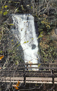 Steep Creek Falls (u)
Rating: **
Form: horsetail
Magnitude: 48
Access: auto (page 225)
USGS Map: Bonneville Dam (1994 nl)
Edition: 1st
Others
North Fork Falls
(u), USGS Lookout Mtn (2000 nl), reportedly is a minor waterfall difficult to see from the nearby trail. Access is not likely to
Greenleaf Falls (u), USGS Bonneville Dam (1994 nl),
Upper Greenleaf Falls (u), USGS Bonneville Dam (1994 nl); or
Greenleaf Peak Falls (u), USGS Bonneville Dam (1994 nl).
Nor are trails or roads shown near Yacolt Burn Falls (u), USGS Lookout Mtn (2000 nl), North Yacolt Burn Falls (u), USGS Lookout Mtn (2000 nl), Middle Rock Creek Falls (u), USGS Lookout Mtn (2000 nl), or Upper Rock Creek Falls (u), USGS Lookout Mtn (2000 nl). An unstable slump has been closed off due to safety concerns, preventing a view of Lower Rock Creek Falls (u), USGS Bonneville Dam (1994 ns)
COPYRIGHT 2013 by Gregory A. Plumb
GUIDEBOOK published by
Mountaineers Books