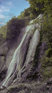
 Munra Falls (u)
Rating: **
Form: fan
Magnitude: 27 (l)
Access: trail (page 210)
USGS Map: Bonneville Dam (1994 ns)
Edition: 2nd
Munra Falls (u)
Rating: **
Form: fan
Magnitude: 27 (l)
Access: trail (page 210)
USGS Map: Bonneville Dam (1994 ns)
Edition: 2nd
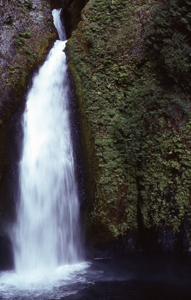 Wahclella Falls
Rating: ****
Form: tiered
Magnitude: 75 (h)
Access: trail (page 210)
USGS Map: Tanner Butte (1994 nl)
Edition: 2nd
More
If you are observant, East Fork Falls (u), USGS Tanner Butte (1994 nl), can be seen from a west-side vantage streaming well above and to the left (east) of Wahclella Falls (described earlier).
Others
Middle Tanner Creek Falls , USGS Tanner Butte (1994 nl), and Upper Tanner Creek Falls (u), USGS Tanner Butte (1994 nl), are very likely inaccessible, as are Wahe Falls, USGS Tanner Butte (1994), Moffett Falls, USGS Tanner Butte (1994 nl) , and Upper Moffett Falls (u), USGS Tanner Butte (1994 nl).
COPYRIGHT 2013 by Gregory A. Plumb
GUIDEBOOK published by
Mountaineers Books