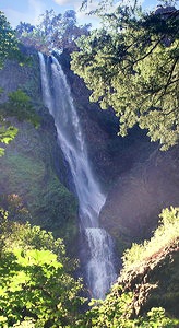
 Starvation Creek Falls
Rating: ****
Form: horsetail
Magnitude: 62
Access: auto (page 218)
USGS Map: Mount Defiance (1994 nl)
Edition: 1st
Starvation Creek Falls
Rating: ****
Form: horsetail
Magnitude: 62
Access: auto (page 218)
USGS Map: Mount Defiance (1994 nl)
Edition: 1st
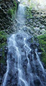 Cabin Creek Falls
Rating: **
Form: horsetail
Magnitude: 32 (l)
Access: trail (page 219)
USGS Map: Mount Defiance (1994 nl)
Edition: 1st
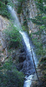 Hole-in-the-Wall Falls
Rating: ***
Form: cascade
Magnitude: 42
Access: trail (page 219)
USGS Map: Mount Defiance (1994 nl)
Edition: 1st
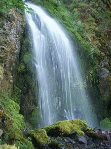 Warren Falls
Rating: **
Form: fan
Magnitude: 35 (l)
Access: trail (page 219)
USGS Map: Mount Defiance (1994 ns)
Edition: 5th
Others COPYRIGHT 2013 by Gregory A. Plumb
Use the following Waterfalls for Intrepid Explorers hyperlink to access an index for information on exploring the following waterfalls:
Lancaster Falls, Mount Defiance (1994)
Summit Creek Falls (u), USGS Mount Defiance (1994 nl)
Lindsey Creek Falls (u), USGS Mount Defiance (1994 nl), would require a substantial bushwhack in order to find it.
Go to next section of Columbia Gorge
Go to previous section of Columbia
Gorge
Columbia Gorge Contents
Columbia Gorge Index
Master Table of Contents
Master Index
Perform a Selective Search
View Chronological List of Additions
View Chronological List of Updates
Place
a Book Order Online
GUIDEBOOK published by
Mountaineers Books