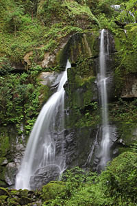
 Elk Creek Falls
Rating: ***
Form: segmented
Magnitude: 32 (l)
Access: trail (page 251)
USGS Map: China Flat (1996)
Edition: 2nd
Elk Creek Falls
Rating: ***
Form: segmented
Magnitude: 32 (l)
Access: trail (page 251)
USGS Map: China Flat (1996)
Edition: 2nd
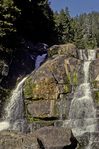 Coquille River Falls
Rating: ***
Form: segmented
Magnitude: 46
Access: trail (page 251)
USGS Map: Illahe (1998)
Edition: 2nd
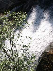 Wooden Rock Creek Falls (u)
Rating: **
Form: horsetail
Magnitude: 45
Access: auto (page 251)
USGS Map: Eden Valley (1998 nl)
Edition: 4th
More
Click Here for Upper Coquille River Falls (u), USGS Illahe (1998 ns). NEW!
Click Here for Cliffside Falls (u), USGS Illahe (1998 ns). NEW!
Others According to their maps, accessibility is unlikely to the following cataracts: Little Dixie Creek Falls (u), USGS Barklow Mtn (1996 nl),
Bone Mountain Falls (u), USGS Rasler Creek (1998 nl);
Myrtle Creek Falls (u), USGS Rasler Creek (1998 nl),
Cole Creek Falls (u), USGS Rasler Creek (1998 nl),
Fall Creek Falls (u), USGS Rasler Creek (1998 nl),
Upper Fall Creek Falls (u), USGS Rasler Creek (1998 nl),
Rock Valley Falls (u), USGS Rasler Creek (1998 nl),
Upper Rock Valley Falls (u), USGS Rasler Creek (1998 nl),
Middle Elk Creek Falls (u), USGS Eden Valley (1998 nl),
Upper Elk Creek Falls (u), USGS Eden Valley (1998 nl),
North Fork Elk Falls (u), USGS Eden Valley (1998 nl),
Coal Creek Falls (u), USGS Eden Valley (1998 nl),
North Coal Valley Falls (u), USGS Eden Valley (1998 nl),
Middle Coal Valley Falls (u), USGS Eden Valley (1998 nl),
South Coal Valley Falls (u), USGS Eden Valley (1998 nl),
South Fork Coal Valley Falls (u), USGS Eden Valley (1998 nl), and
Upper South Coal Valley Falls (u), USGS Eden Valley (1998 nl).
COPYRIGHT 2013 by Gregory A. Plumb
Use the following Waterfalls for Intrepid Explorers hyperlink to access an index for information on exploring the following waterfalls:
Lower North Fork Elk Falls (u), USGS China Flat (1996 nl)
Middle Coquille River Falls (u), USGS Illahe (1998 nl)
Go to next section of South Coast Range
Go to previous section of South Coast
Range
South Coast Range Contents
South Coast Range Index
Master Table of Contents
Master Index
Perform a Selective Search
View Chronological List of Additions
View Chronological List of Updates
Place
a Book Order Online
GUIDEBOOK published by
Mountaineers Books