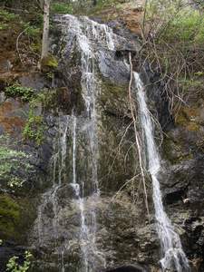
 Mouse Creek Falls (u)
Rating: **
Form: segmented
Magnitude: 19 (l)
Access: auto (page 252)
USGS Map: Galice (1998 nl)
Edition: 4th
More Others COPYRIGHT 2013 by Gregory A. Plumb
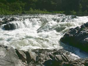 Rainie Falls
Rating: **
Form: block
Magnitude: 32 (h)
Access: trail (page 253)
USGS Map: Mount Reuben (1998)
Edition: 4th
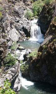 Stair Creek Falls
Rating: ***
Form: tiered
Magnitude: 65
Access: trail (page 253)
USGS Map: Marial (1998)
Edition: 4th
Click Here for Grave Creek Falls, USGS Marial (1998).
Output the CLICK HERE page to match your hardcopy book by changing your printer settings to 9" x 5 3/4".
Use the following Waterfalls for Intrepid Explorers hyperlink to access an index for information on exploring the following waterfalls:
Silver Falls, USGS York Butte (1998)
Flora Dell Falls (Rogue River), USGS Illahe (1998 ns)
The lower Rogue River cuts through the Klamath Mountains portion of the Coast Range, creating a 2,000-foot-deep canyon. A 35-mile stretch of it is designated a Wild River, a federal classification
intended to provide river recreation in a primitive setting and to preserve the natural, untamed integrity of the river and its surrounding environment. As documented by the Rogue River Float Guide, the following rapids can be encountered along the river, either by hiking and/or rafting: Upper Black Bar Falls , USGS Bunker Creek (1998), Lower Black Bar Falls, USGS Bunker Creek (1998) and Kelsey Falls, USGS Kelsey Peak (1998 ns). The following waterfalls (forest cover masks them from aerial imagery) descend from small tributaries pouring into the canyon: Tate Creek Falls, USGS Marial (1998 nl), Dulog Falls, USGS Kelsey Peak (1998 ns), and Fall Creek Falls, USGS Marial (1998).
According to their topographic maps, accessibility is unlikely to Briggs Creek Falls (u), USGS Chrome Ridge (1996 nl), Taylor Creek Falls, USGS Onion Mtn (1996), Secret Creek Falls (u), USGS Onion Mtn (1989 nl), North Silver Creek Falls (u), USGS Hobson Horn (1989 nl), East Indigo Creek Falls (u), USGS Hobson Horn (1989 nl), and Schoolmarm Creek Falls (u), USGS Galice (1998 nl).
Go to next section of South Coast Range
Go to previous section of South Coast
Range
South Coast Range Contents
South Coast Range Index
Master Table of Contents
Master Index
Perform a Selective Search
View Chronological List of Additions
View Chronological List of Updates
Place
a Book Order Online
GUIDEBOOK published by
Mountaineers Books
)
)