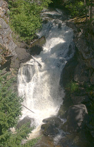
 Crystal Falls
Rating: ***
Form: tiered
Magnitude: 75 (h)
Access: auto (page 187)
USGS Map: Park Rapids (1992)
Edition: 1st
Crystal Falls
Rating: ***
Form: tiered
Magnitude: 75 (h)
Access: auto (page 187)
USGS Map: Park Rapids (1992)
Edition: 1st
More
Click Here for Exley Falls, USGS Fan Lake (1980 nl). NEW!
Output the CLICK HERE page to match your hardcopy book by changing your printer settings to 9" x 5 3/4".
Others
Content has been removed from the web site that once described a tough bushwhack to Dovetail Falls (u), USGS Fan Lake (1980 ns). Considering there is a lot of private property in the area, perhaps that is the reason why.
The lodge bearing the name of Cedar Falls, USGS Camden (1980 ns), is now closed with no trespassing on the property.
Nothing more than a riffle could be found at Calispell Creek Falls (u),
USGS Sacheen Lake (1992 nl).
COPYRIGHT 2013 by Gregory A. Plumb
GUIDEBOOK published by
Mountaineers Books