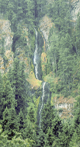
 Skookum Falls
Rating: **
Form: tiered
Magnitude: 32 (l)
Access: auto (page 134)
USGS Map: Sun Top (1986 nl)
Edition: 1st
Skookum Falls
Rating: **
Form: tiered
Magnitude: 32 (l)
Access: auto (page 134)
USGS Map: Sun Top (1986 nl)
Edition: 1st
More
Click Here for Snoquera Falls, USGS Sun Top (1986 nl).
Click Here for Dalles Falls (u), USGS Sun Top (1986 ns).
Output the CLICK HERE pages to match your hardcopy book by changing your printer settings to 9" x 5 3/4".
Doe Falls, USGS Sun Top (1986 ns), is a six-mile round-trip hike according to this U.S. Forest Service web page.
Others COPYRIGHT 2013 by Gregory A. Plumb
When field truthed in April, 2011, public access was prohibited by the local timber company to Boise Creek Falls (u), USGS Enumclaw (1997 ns).
Access is quite unlikely to Falls Creek Falls (u), USGS Bearhead Mtn (1986 nl),
Upper Falls Creek Falls (u), USGS Bearhead Mtn (1986 nl),
East Canyon Creek Falls (u), USGS Bearhead Mtn (1986 nl),
West Canyon Creek Falls (u), USGS Bearhead Mtn (1986 nl).
Go to next section of Mount Rainier
Go to previous section of Mount Rainier
Mount Rainier Contents
Mount Rainier Index
Master Table of Contents
Master Index
Perform a Selective Search
View Chronological List of Additions
View Chronological List of Updates
Place
a Book Order Online
GUIDEBOOK published by
Mountaineers Books