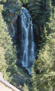
 Mesatchee
Creek Falls
Mesatchee
Creek Falls
Rating: ***
Form: horsetail
Magnitude: 72
Access: trail (page 135)
USGS Map: Norse Peak (2000 nl)
Edition: 1st
Mesatchee
Creek Falls
Rating: ***
Form: horsetail
Magnitude: 72
Access: trail (page 135)
USGS Map: Norse Peak (2000 nl)
Edition: 1st
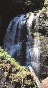 Union
Creek Falls
Union
Creek Falls
Rating: ***
Form: horsetail
Magnitude: 64
Access: trail (page 136)
USGS Map: Goose Prairie (2000)
Edition: 1st
More
Click Here for Copper Creek Falls (u), USGS Bumping Lake (2000 ns).
Click Here for Lower Deep Creek Falls (u), USGS Bumping Lake (2000 ns).
Click Here for Lower Bumping River Falls (u), USGS Bumping Lake (2000 ns).
Click Here for Bumping River Falls (u), USGS Bumping Lake (2000 nl).
Output the CLICK HERE page to match your hardcopy book by changing your printer settings to 9" x 5 3/4".
COPYRIGHT 2013 by Gregory A. Plumb
GUIDEBOOK published by
Mountaineers Books