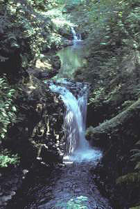
 Kennedy Falls
Rating: **
Form: tiered
Magnitude: 38
Access: trail (page 106)
USGS Map: Kamilche Valley (1981)
Edition: 1st
Kennedy Falls
Rating: **
Form: tiered
Magnitude: 38
Access: trail (page 106)
USGS Map: Kamilche Valley (1981)
Edition: 1st
More
Click Here for Goldsborough Falls (u), USGS Shelton (1981 nl).
Output the CLICK HERE page to match your hardcopy book by changing your printer settings to 9" x 5 3/4".
COPYRIGHT 2013 by Gregory A. Plumb
GUIDEBOOK published by
Mountaineers Books