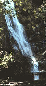
 Madison Falls
Rating: **
Form: horsetail
Magnitude: 47
Access: auto (page 89)
USGS Map: Elwha (1985 ns)
Edition: 1st
Update: This is now an offically named waterfall and the NPS park map labels a trail to it.
Madison Falls
Rating: **
Form: horsetail
Magnitude: 47
Access: auto (page 89)
USGS Map: Elwha (1985 ns)
Edition: 1st
Update: This is now an offically named waterfall and the NPS park map labels a trail to it.
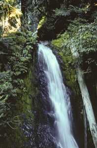 Wolf Creek Falls (u)
Rating: ***
Form: horsetail
Magnitude: 41
Access: trail (page 90)
USGS Map: Hurricane Hill (2003 nl)
Edition: 1st
Others COPYRIGHT 2013 by Gregory A. Plumb
Use the following Waterfalls for Intrepid Explorers hyperlink to access an index for information on exploring the following waterfalls yet to be visited by the author:
Marys Falls, USGS Mount Angeles (2003 nl)
Martins Falls (u), USGS Mount Christie (2003 nl)
PJ Lake Falls (u) (u), USGS Mount Angeles (2003 ns)
Seattle Creek Falls (u), USGS Mount Christie (2003 nl), is not near any trails, nor is Godkin Falls (u), USGS Chimney Peak (1990 nl), . The topographic map implies Morse Creek Falls (u), USGS Morse Creek (1985 nl) as inaccessible. The following cataracts are remote and most likely inaccessible: Service Falls, USGS Mount Olympus (2003 nl), Upper Service Falls (u), USGS Mount Olympus (2003 nl), and the pair of
Elwha Valley Falls (u), USGS Mount Queets (1990 nl).
Go to next section of Olympics
Go to previous section of Olympics
Olympics Contents
Olympics Index
Master Table of Contents
Master Index
Perform a Selective Search
View Chronological List of Additions
View Chronological List of Updates
Place
a Book Order Online
GUIDEBOOK published by
Mountaineers Books