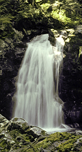
 Lower Boulder Creek Falls
Rating: **
Form: horsetail
Magnitude: 48
Access: trail (page 90)
USGS Map: Mount Carrie (1965 nl)
Edition: 1st
Lower Boulder Creek Falls
Rating: **
Form: horsetail
Magnitude: 48
Access: trail (page 90)
USGS Map: Mount Carrie (1965 nl)
Edition: 1st
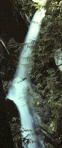 Upper
Boulder Creek Falls
Upper
Boulder Creek Falls
Rating: **
Form: tiered
Magnitude: 56
Access: trail (page 91)
USGS Map: Mount Carrie (1965 nl)
Edition: 1st
Others COPYRIGHT 2013 by Gregory A. Plumb
Use the following Waterfalls for Intrepid Explorers hyperlink to access an index for information on exploring the following waterfalls yet to be visited by the author:
Bridge Creek Falls (u), USGS Mount Carrie (1965 nl)
Hoh Lake Falls(u), USGS Bogachiel Peak (1950 nl)
Go to next section of Olympics
Go to previous section of Olympics
Olympics Contents
Olympics Index
Master Table of Contents
Master Index
Perform a Selective Search
View Chronological List of Additions
View Chronological List of Updates
Place
a Book Order Online
GUIDEBOOK published by
Mountaineers Books