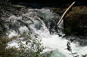
 Salmon Creek Falls
Rating: **
Form: segmented
Magnitude: 47 (h)
Access: auto (page 288)
USGS Map: Huckleberry Mtn (1997)
Edition: 1st
Salmon Creek Falls
Rating: **
Form: segmented
Magnitude: 47 (h)
Access: auto (page 288)
USGS Map: Huckleberry Mtn (1997)
Edition: 1st
 Needle Falls (u)
Rating: **
Form: segmented
Magnitude: 21 (l)
Access: auto (page 288)
USGS Map: Huckleberry Mtn (1997 nl)
Edition: 4th
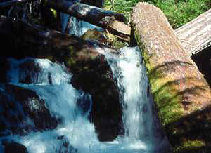 Lillian Falls
Rating: **
Form: cascade
Magnitude: 25
Access: trail (page 288)
USGS Map: Waldo Lake (1997)
Edition: 1st
More
Click Here for Pine Creek Falls (u) (u), USGS Warner Mtn (1997 nl) .
Output the CLICK HERE page to match your hardcopy book by changing your printer settings to 9" x 5 3/4".
Others COPYRIGHT 2013 by Gregory A. Plumb
Use the following Waterfalls for Intrepid Explorers hyperlink to access an index for information on exploring the following waterfall:
Youngs Creek Falls (u), USGS Warner Mtn (1997
nl)
Falls. No access is shown to Fir Creek Falls (u), USGS Warner Mtn (1986 nl),
Upper Fir Creek Falls (u), USGS Warner Mtn (1986 nl), Estep Creek Falls (u), USGS Warner Mtn (1986 nl)
Coal Valley Falls (u), USGS Staley Ridge (1997 nl).
Go to next section of South Cascades
Go to previous section of South Cascades
South Cascades Contents
South Cascades Index
Master Table of Contents
Master Index
Perform a Selective Search
View Chronological List of Additions
View Chronological List of Updates
Place
a Book Order Online
GUIDEBOOK published by
Mountaineers Books