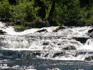
 Trout Lake Creek Falls (u)
Rating: **
Form: rapids
Magnitude: 16
Access: auto (page 175)
USGS Map: Guler Mtn (2000 ns)
Edition: 5th
Trout Lake Creek Falls (u)
Rating: **
Form: rapids
Magnitude: 16
Access: auto (page 175)
USGS Map: Guler Mtn (2000 ns)
Edition: 5th
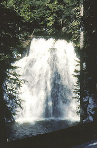
 Little Goose Creek Falls
Rating: ***
Form: segmented
Magnitude: 80
Access: bushwhack (page 175)
USGS Map: Sleeping Beauty (2000 ns)
Edition: 1st
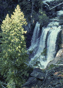
 Langfield Falls
Rating: ****
Form: fan
Magnitude: 86
Access: trail (page 176)
USGS Map: Sleeping Beauty (2000)
Edition: 1st
More
Click Here for Tillicum Creek Falls (u), USGS Quartz Creek Butte (2011 ns).
Others COPYRIGHT 2013 by Gregory A. Plumb
Use the following Waterfalls for Intrepid Explorers hyperlink to access an index for information on exploring the following waterfalls yet to be visited by the author:
Little Niagara Falls, USGS Quartz Creek Butte (2011)
Lost Creek Falls (u), USGS Little Huckleberry Mtn (1998 nl)
Dry Creek Falls (u), USGS Little Huckleberry Mtn (1998 nl), is not likely accessible.
Go to next section of Gifford Pinchot
Country
Go to previous section of Gifford
Pinchot Country
Gifford Pinchot Country Contents
Gifford Pinchot Index
Master Table of Contents
Master Index
Perform a Selective Search
View Chronological List of Additions
View Chronological List of Updates
Place
a Book Order Online
GUIDEBOOK published by
Mountaineers Books