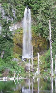
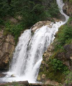
 June Lake Falls (u)
Rating: ***
Form: plunge
Magnitude: 61
Access: trail (page 159)
USGS Map: Mount St Helens (1998 ns)
Edition: 4th
June Lake Falls (u)
Rating: ***
Form: plunge
Magnitude: 61
Access: trail (page 159)
USGS Map: Mount St Helens (1998 ns)
Edition: 4th
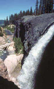 Upper Lava Canyon Falls (u)
Rating: **
Form: plunge
Magnitude: 51 (h)
Access: trail (page 159)
USGS Map: Smith Creek Butte (2000 nl)
Edition: 3rd
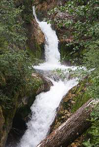
 Triplet Falls (u)
Rating: ***
Form: tiered
Magnitude: 47 (h)
Access: trail (page160)
USGS Map: Smith Creek Butte (2000 ns)
Edition: 4th
 Double Punchbowl Falls (u)
Rating: **
Form: tiered
Magnitude: 40 (h)
Access: trail (page 160)
USGS Map: Smith Creek Butte (2000 ns)
Edition: 4th
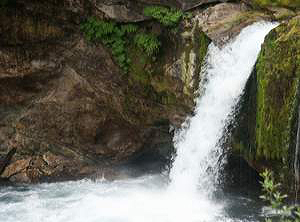
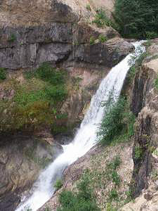 Lava Canyon Falls (u)
Rating: *****
Form: tiered
Magnitude: 81 (h)
Access: trail (page 160)
USGS Map: Smith Creek Butte (2000 nl)
Edition: 4th
 Middle Lava Canyon Falls (u)
Rating: ***
Form: tiered
Magnitude: 66 (h)
Access: trail (page 161)
USGS Map: Smith Creek Butte (2000 nl)
Edition: 4th
 Lower Lava Canyon Falls (u)
Rating: **
Form: tiered
Magnitude: 70 (h)
Access: trail (page 161)
USGS Map: Smith Creek Butte (2000 nl)
Edition: 4th
Others COPYRIGHT 2013 by Gregory A. Plumb
Use the following Waterfalls for Intrepid Explorers hyperlink to access an index for information on exploring the following waterfall yet to be visited by the author:
Chocolate Falls, USGS Mount St Helens (1998 ns)
Upper Sheep Canyon Falls (u) (u), USGS Mount St Helens (1998 ns)
Sheep Canyon Falls (u) (u), USGS Mount St Helens (1998 ns)
Go to next section of Gifford Pinchot
Country
Go to previous section of Gifford Pinchot
Country
Gifford Pinchot Country Contents
Gifford Pinchot Index
Master Table of Contents
Master Index
Perform a Selective Search
View Chronological List of Additions
View Chronological List of Updates
Place
a Book Order Online
GUIDEBOOK published by
Mountaineers Books